


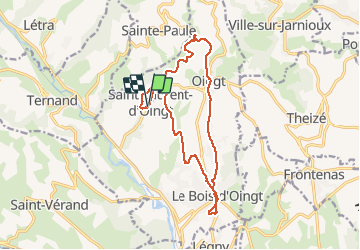
Tour du Val d'Oingt en passant par les 3 clochers

adye
User


1h11
Difficulty : Medium
1h30
Difficulty : Medium
1h20
Difficulty : Medium

FREE GPS app for hiking
 SityTrail
IGN / Geographical institutes
SityTrail Plus
The world is yours!
About
Trail Road bike of 16.1 km to be discovered at Auvergne-Rhône-Alpes, Rhône, Val d'Oingt. This trail is proposed by adye.
Description
Départ Saint-Laurent d'Oingt, chapelle du Mont Joli, Mussy, Bornigat,
Oingt, le vieux village, les Crêtes,
Le Bois d'Oingt, Malvaisson, la place, le Vieux village, Combefort
Retour Saint-Laurent-d'Oingt par Montgelin, Guerillon et Oyasson
Essentiellement sur routes goudronnées, sauf la jonction sortie d'Oingt/haut du Bois-d'Oingt, qui peut être reliée par la route (via la départementale).
Positioning
Comments